About Variometer-Sky Land Tracker
This app always knows and uses the current location even when running in the foreground as well as in the background. Approved CIVL flight instrument for FAI Category...
This app always knows and uses the current location even when running in the foreground as well as in the background.
Approved CIVL flight instrument for FAI Category 1.(https://www.fai.org/page/civl-xc-instrument-accepted)
Variometer, Vario, G_Vario, G_Variometer, Tracker (Compatible for GPS only or Phone Baro Sensor or FlyNet2 or BlueFlyVario or GoFly Pico), 3D Track View with 3D terrain maps.
Paragliding, hang gliding and all air sports, Radio Control Plane and skiing, sailing, mountain climbing, etc.
Portal tracker instruments for all Outdoor sports.
Support Offline map as MapsForge(.map) offline map
Support FAI-CIVL(http://vali.fai-civl.org/supported.html) valid IGC files. (GNSS : http://g-variometer-vali.blogspot.kr)
Flight instruments is expensive, but your phone is also expensive equipment.
Your phone is better than that , you can perform a variety of functions.
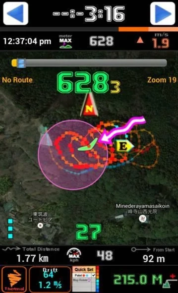
Using Compass & GPS & Pressure Sensor, flight time, speed, altitude, vertical speed, L/D is displayed.
If your phone is equipped with pressure sensor, In air sports mode, variometer functions can be maximized.
Pressure Sensor sensitivity of this filter using the Fourier Transform is better than any other filter using a simple lowpass filter or kalman.
Therefore more precise user setting is possible.
After simple one click, Ready to take off at once, auto-start-stop, manual-start-stop is possible
Big font and high contrast raised the visibility in outdoor.
Through manual built in the app, you can learn easily how to use.
Flight time, battery level, GPS status, and vertical speed, maximum speed, speed, maximum altitude, altitude, Hpa pressure, temperature (varies by altitude), weather (wind direction, wind speed), Task orientation, remaining distance, the total path length, Fuel Gage(for Motor Skysports) are displayed
It displays the direction and intensity of drift and thermal detecting also.
Waypoint and Route creation is easier and faster than any other app.
Waypoint Import Export Support (WPT, CUP format)
Map of the Google, OSM, GoogleV2 is used in various ways.
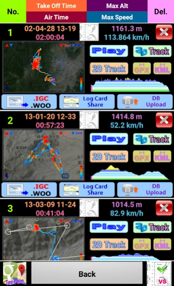
Track play function is best function same as seeing the actual flight.
Indexing and rewinding and the execution speed can be adjusted.
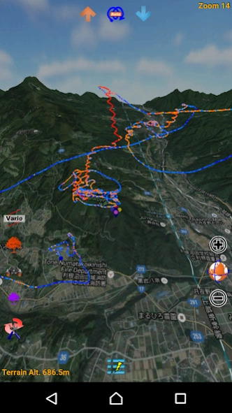
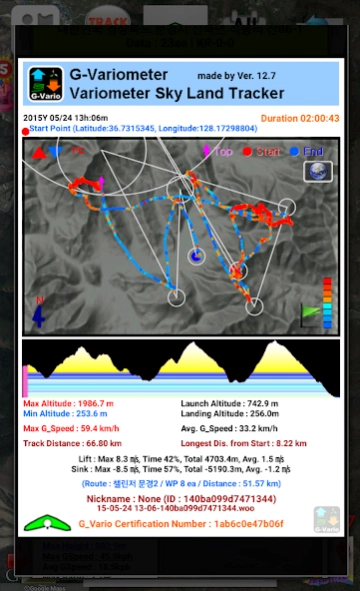
You can also see in 3D Track(shared track) with 3D terrain maps(shared track).
Seeing track thumbnail, you can easily find a specific flight record and
Your indexing speed can be also fast through altitude graph.
Track files can be sent via email to other users and
In addition, KML, GPX files are saved and automatically converted.
Navigation displays to the users the real-time shortest course from the current location and flight direction to next task, remaining distance, needed altitude against glide ratio
In briefing, share discussion with colleagues easy.
The units (mile, feet, meter, knot, ft / s, m / s, mph, kph, ℃, ℉) can be freely selected.
Coordinate system of the DD-MM-SS.SS, UTM, WGS84, etc can be selected
When performing in background Mode, track can be recorded throughout the day precisely and
During the mode, the sonic variometer functions and task passing, starting height sound alarm can be performed continuously.
The altitude can be set in a variety of ways.
Based Terrain Elevation, sea level air pressure reference, GPS altitude, the user manual setting is possible.
GPS environment will be best in flight, You can get reliable performance.
The following specific rights are
android.permission.ACCESS_GPS
android.permission.GET_ACCOUNTS
Direct GPS connection is required due to FAI IGC file creation regulations,
We use a user account to make it convenient for you to share your track files.
For feature requests and uncomfortable, please send mail to.
[email protected]
Previous Versions
Here you can find the changelog of Variometer-Sky Land Tracker since it was posted on our website on 2014-06-13 02:25:54.
The latest version is 25.7 and it was updated on 2024-04-01 17:44:12. See below the changes in each version.
Variometer-Sky Land Tracker version 25.7
Updated At: 2023-08-20
Changes: 1. Android SDK 33 Targeting
2. Small BugFix
Variometer-Sky Land Tracker version 25.6
Updated At: 2022-04-29
Changes: 1. BugFix:Eliminate button click interference on the Scrollbar etc.
2. Fix 3D Play to play smoothly
3. Vario Sound Improvement & ULP_Mode's floating icon link Bug Fix
4. Android policy response and stability improvement
5. MapsForge Offline Map Add Contour
6. Android R(11) version correspondence update
7. Update map version of 2D Track view
8. API Key Security and Unzip Security Updates
Variometer-Sky Land Tracker version 25.4
Updated At: 2022-04-14
Changes: 1. BugFix:Eliminate button click interference on the Scrollbar
2. Fix 3D Play to play smoothly
3. Vario Sound Improvement & ULP_Mode's floating icon link Bug Fix
4. Android policy response and stability improvement
5. MapsForge Offline Map Add Contour
6. Android R(11) version correspondence update
7. Update map version of 2D Track view
8. API Key Security and Unzip Security Updates
Variometer-Sky Land Tracker version 25.3
Updated At: 2022-04-06
Changes: 1. Fix 3D Play to play smoothly
2. Vario Sound Improvement & ULP_Mode's floating icon link Bug Fix
3. Android policy response and stability improvement
4. MapsForge Offline Map Add Contour
5. Android R(11) version correspondence update
6. Update map version of 2D Track view
7. API Key Security and Unzip Security Updates
Variometer-Sky Land Tracker version 25.2
Updated At: 2022-04-03
Changes: 1. Vario Sound Improvement & ULP_Mode's floating icon link Bug Fix
2. Android policy response and stability improvement
3. MapsForge Offline Map Add Contour
4. Android R(11) version correspondence update
5. Update map version of 2D Track view
6. API Key Security and Unzip Security Updates
Variometer-Sky Land Tracker version 24.9
Updated At: 2022-03-20
Changes: 1. Android policy response and stability improvement
2. MapsForge Offline Map Add Contour
3. Android R(11) version correspondence update
4. Update map version of 2D Track view
5. API Key Security and Unzip Security Updates
Variometer-Sky Land Tracker version 24.3
Updated At: 2021-03-09
Changes: [Version 24.3]
1. Response to policy on using location information in background
Variometer-Sky Land Tracker version 24.1
Updated At: 2020-10-17
Changes: [Version 24.1]
1. Update for Android Q(10) version
Variometer-Sky Land Tracker version 23.9
Updated At: 2020-01-16
Changes: [Version 23.9]
1. Correspond to change of weather information parsing API
Variometer-Sky Land Tracker version 23.8
Updated At: 2019-06-29
Changes: [Version 23.8]
1. Responding to an error occurred by Android version when uploading DB
2. 3D play small improvement